| CAVES: Wild Ones in Cumberland County, Pennsylvania by Keyzine.com |
|
|
|
|
| It has been years since
I have thought
of this type of an outing. It took our recent involvement with Vacation
Bible School at our church - which had a theme of "caves" - to
reminding me
of our spelunking adventures from decades past. These were to remote
locations right here in our local Cumberland County
area. Many may be surprised by what can be found in the area. The
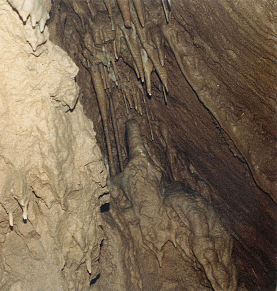
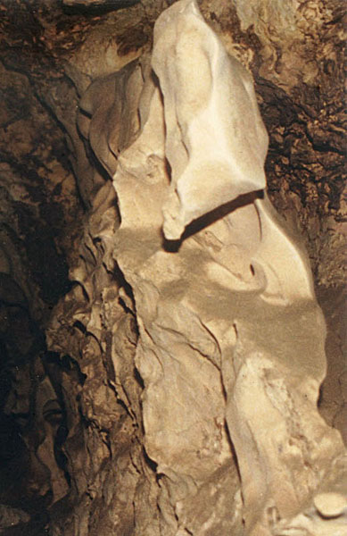
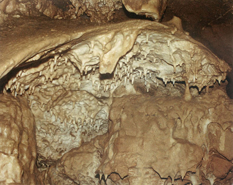
photos above are from Cleversburg Sink in
Shippensburg. For my first visit to this cave, found at the bottom of a
very
large sinkhole, the water table was rather high and once we
had
descended into the
first opening for a room, there really was no further we could go
without getting very wet. Seeing the bottom of the room filled with
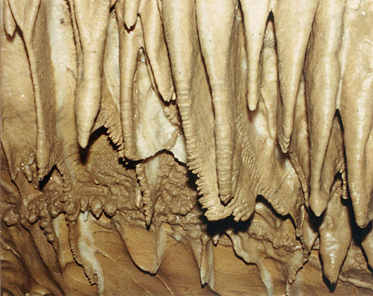
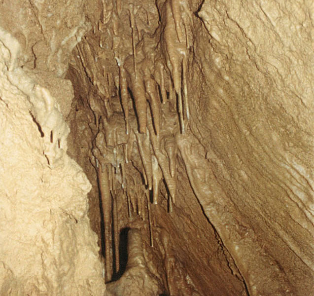
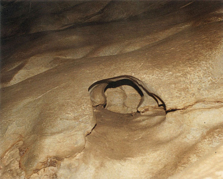
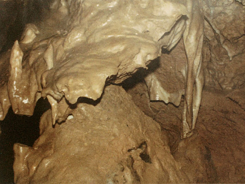
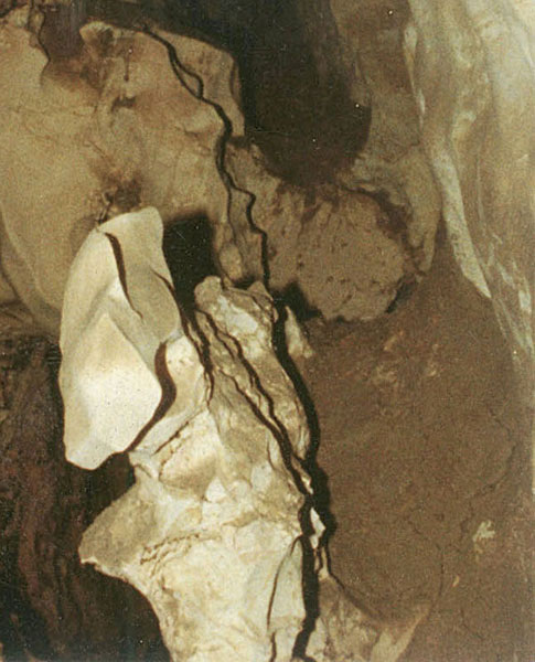
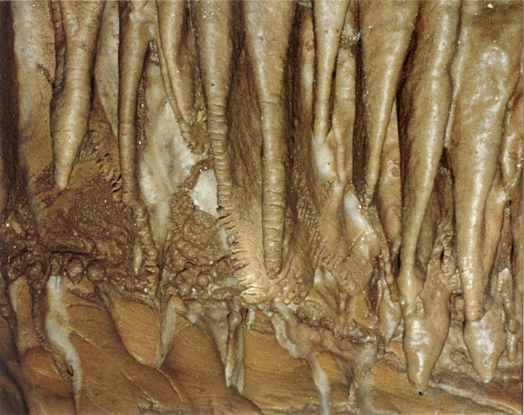
crystal clear water was a memorable sight. Years later revisiting this same cave, much more was available for exploring. Some of the photos above show clean areas of eroded rock that would have been mostly underwater and restricted from the expected formation of cave features. Other photos show those areas where formations took place. Being remote, many of these delicate details remained undisturbed and undamaged. Though caves can be found throughout the county, the map below focuses on one specific area just east of Shippensburg. Many may be aware of Cleversburg Sink since it has been well documented and due to its convenient location next to a township park. Carnegie Cave too has been visited by many and is unique in that access to this cave was retained even though Interstate Rt. 81 was built directly overhead. The path to the cave's entrance is by way of a drainage pipe that goes under the north-bound lanes of the highway - with the cave itself residing under the highway and its median. 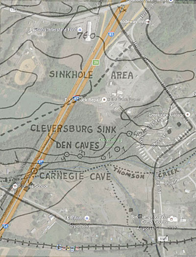 The map above is a combination of a current Google Map view along with a detail from an historic map from Mid-Appalachian Region of the National Speleological Society, dated 1958, and other maps referenced below, and as displayed at the cave site, were from this same source. Both Cleversburg Sink and Carnegie Cave is shown (above) along with other "den caves" that were found in the area. In addition, just northwest of this area there were two other caves that were also identified in this general area along Burd and Thomson creeks. And for Rt. 81, this was not yet built. From what I can find the Exit 29 area of the highway was not completed until around 1964-65. 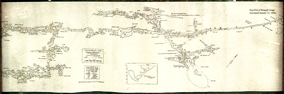 The map above is of Cleversburg Sink with the entrance shown on the right bottom. The dotted line represents the top of the sinkhole. 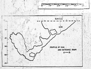 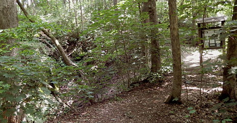 For scale and for a closer look at the sinkhole entrance, the map detail above shows the top of the sink as being around forty feet across. The walk from the township park is easy to follow, and upon reaching the top of the hill the large sink is hard to miss. The photo above does not do justice for seeing this in person and only shows a small portion of the sink. To the right is found a bulletin board which displays much information. Dropping to the bottom of the sink, the entrance is locked and gated, and for size, seems not large enough for dropping into. Though it appears that there is a second opening to the cave, I do not recall seeing this in person. Would guess it would be too small for entry, and if not, then would likewise be restricted. 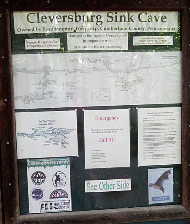  This detail (above) of Cleversburg Sink shows a bit more of what is found beyond the entrance. Initially the size of this cave was thought to be only around 400 to 500 feet in size - which no doubt was with first noticing (when the water level was low enough) the east to west direction of the main passageway. The northeast and southwest branches, being more restrictive in size, were not fully realized until surveys of the cave were made in the 1950s. The size then was estimated as being close to 3,000 feet, and judging from what is displayed on the bulletin board at the cave site, even more areas of the cave have been discovered since the 1950s. (For source information please follow links provided at end of this article.) 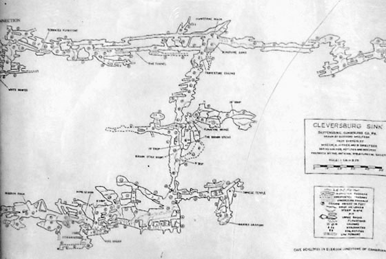  And this detail shows the far left (southwest) portion of the cave. Note the map legend indicates that the numbers in circles on the map are for indicating the "ceiling height in feet" - which should give you a sense for how restricted and tight some of these spaces are. To even reach the southwest portion of the cave you need to "worm" your way through some very narrow parts (see below) with ceiling heights of only one or few feet. Though I have travelled through some tight spots in other caves, for Cleversburg Sink I do not recall reaching these parts of the cave. The photos at the start of this article, if I recall correctly, are of areas to the right (northeast) side of the cave. 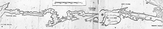 It is especially difficult to imagine someone being able to traverse these sections to find (and to also document and map) those hidden sections of the cave. My description of such challenges would be that there can be places where there is not enough room to leave your helmet on your head, and for light, the helmet is held out in front of you. And too for arm position, if elbows are extended beyond your shoulders then at times there would be not enough room - due to the length of your upper arm - to pivot your elbow from in front to behind your shoulder for backing out of the situation if need be. Hopefully you can move forward to an area large enough so that your body can be reversed for the return trip - otherwise you would need to inch your way backwards, and hope your clothing, your gear, or anything on your body which would be out of reach, does not get caught on anything. It would be fair to say there are reasons why exploring such remote regions of wild caves should be reserved for those with the expertise and experience needed to ensure a safe experience. For more information about Cleversburg Sink, you can visit the Mid-Atlantic Karst Conservatory site (www.karst.org/...) which has a lot to offer. And relating to our local county history it is interesting to see some familiar names listed as being first visitors to the cave. Evidently in "the Pennsylvania Geolologic Survey, dated 1932" there is a reference to the cave being "discovered by [Eugene] M. Craighead, while hunting in the area...with Frank Masland of Carlisle..." and that the "first recorded trip into the cave was in 1931...." (For more information about Eugene and the Craighead family visit craigheadhouse.org.) Also found on the Karst.org site are some photos and "Articles" - one in particular describing the replacement of the ladder within the cave which provides some sense for the larger spaces and vertical challenges this cave has to offer. In addition to this, the article describing the "Water Level Research" - relating to the extreme fluctuation of the water table level - is especially interesting to read. And for an indepth analysis, visit www.ship.edu/... for review of the 2009 research report relating to the groundwater in the Cleversburg Sink area.  Realizing that it has been decades since I have seen this cave - or any wild cave for that matter - in person, I hope that the formations and details, as partly described on these maps, are still in good shape. I appreciate the efforts made by others for conservation and for providing an avenue (such as through caving clubs) for exploring these remote spots - with respect for what can be found there, and with respect for the dangers that can accompany such outings.... Safe spelunking to all who choose this kind of adventure.... ~~~ |